
Backpacking the Rincons
- rickconquered
- May 18, 2016
- 6 min read


This past weekend Mike, my dad, and I went on a three day/two night backpacking adventure over the Rincon Mountains in Tucson, AZ. Enjoy reading about our trip!
I encourage you to listen to some good backpacking inspired music while you peruse. Brett Dennen - Wild Child:
Day 1: Loma Alta Trail - Quilter Trail - Manning Camp Trail - Grass Shack Campground

Distance: 10.7 miles
Elevation Gain: 2,600 ft
Hot, Wet, and Gnat-sty

Mike and I started our day bright and early, picked up my dad and hit the trail before 7:00am. As soon as we got out of the car we noticed the gnats, they were a bother but once we started moving they disbursed. It was a beautiful morning strolling along the Loma Alta Trail. We ran into a few groups of mountain bikers and it seemed like it was going to be a perfect day. After about 2.5 miles we left the Loma Alta Trail behind and started up the Quilter Trail.
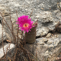
When we took our first break we all noticed that the gnats had become swarms. We could not sit down and take a breather without literally being covered in gnats. Due to the warm weather, Mike and I both wore short sleeves and shorts - the gnats were so attracted to our sweaty skin they just constantly landed on us. The picture below shows the gnat accumulation on my legs over the period of time it took to take an iPhone photo. They became an ongoing issue over the course of the day. After this, our first and extremely brief, rest we started our climb.

We had no wind, hot sun, and little resting ability due to the gnat attack. These external factors combined with a heavy pack and likely poor preparation on my part, resulting in me suffering from dehydration. About half way to Grass Shack, I questioned if I could make it at all. I dumped a liter of water on my head, drank electrolyte water, Mike took some of my pack weight, and I sat and rested even with the gnats completely attacking us. I decided to keep going, albeit very slowly. From here the going was tough, it was very hot and you can't really fully recover from dehydration while you continue working in the sun. But we had plenty of water and just rested a lot and tried our damnedest to ignore the gnats.

About 1 mile from the campground we took (another) break and decided to have some lunch. While eating we watched storm clouds brewing and a curtain of rain come down in the canyon adjacent to the ridge we were hiking up. Suddenly the wind shifted and the curtain was headed right toward us! We quickly packed up lunch and threw on our rain coats and pack covers. We waited it out for a little while and were able to get the campsite during a brief reprieve from the rain and get the tents set up - only slightly damp. Then the thunderstorms came, a long steady rain for about 2 hours. We just laid in our tents, resting our tired bodies and let it rain. That picture is me waiting out the rain in the tent. But, hey at least it took care of most of the gnats!
This was probably the toughest hiking day for me. Had I not pushed myself into heat stroke it would have been great, but I really didn't listen to my body and it made for a bad time. Thanks to Mike and my dad I was able to complete the day, and thanks to Mother Nature for bringing the rain that forced me to lay down for a few hours as soon as I got to camp.


Day 2: Manning Camp Trail - Manning Camp
Distance: 4.9 miles
Elevation Gain: 3,000 ft.
My Favorite Spot In The World
Up with the sun, drink lots of water, some electrolytes, streeeeeeeetch out, and eat a small breakfast. What happened yesterday will not happen today! I was nervous, lots of climbing today.
We hit the trail around 7:45am, gnat free. There was no warming up to this incline, we immediately started up, up up. The trail was maintained perfectly, lots of steps and gradual switch backs.


We plodded along slowly, enjoying the amazing views. We quickly left the junipers and oaks and found ourselves in a pine forest. Every break and overlook was more beautiful than the last. The weather was cool, a pleasant change from yesterday's sizzling heat. THIS is what backpacking is about! Nearing camp we spotting two deer just off the trail, they were curious of our presence, but not scared.
For lunch we sat on a rock outcropping and watched a flock of ravens play in the wind as it whipped up Chiminea Canyon. The incline didn't seem as bad since every second I was mesmerized by my surroundings.
Arriving at Manning Camp around noon - I was completely blown away by this place!


The Manning Camp Trail is actually an old wagon road. The Manning family constructed it in 1906 to get up to their summer cabin tucked near the top of the Rincon's. The cabin is now used by the Forest Service. The cabin had so many resources for the Forest Service personnel - cords of wood, a table with padded chairs, a rope swing, and even a bench press with LOTS of weight! The campground was just amazing, especially for the backcountry. Each site has it own metal enclosed fire ring and benches. There is a deep pool for filtering water. And there were clean composting toilets! I could see how someone could spend a lot of time here.


As the day progressed it got VERY windy and chilly. We built a fire in the handy fire ring and enjoyed the evening. We even were able to partake in some of our backpacking essentials - boxed wine (the boy had bourbon), chocolate and peanut butter. Who says you can't keep it classy? Just before sunset we hiked up to a helicopter landing pad and tried to watch the sunset. I got to be too chilly, so before dark we headed back to camp and huddled around the fire. It was a cold night in the tents, but not uncomfortable.

Day 3: Manning Camp Trail - Spud Rock - Mica Mountain - Italian Springs Trail - Redington Pass
Distance: about 12 miles (there were some discrepancies in the signs)
Elevation Loss: 4,672 ft
This Is Probably Impossible
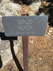
Long day ahead of us, so we wanted to leave a bit earlier. I woke up to discover a mosquito joined me in my sleeping bag...grrr. At least I was feeling good and ready for the big day ahead. This was it - finally we would reach the summit! Hit the trail around 7:15am and climbed for about 1.5 miles to Spud Rock. Clamored our way to the top, and saw the most amazing 360 degree views. Words and pictures cannot explain the glory that this was.


My dad was able to point out where the car was parked. I was pretty sure he was wrong, because it seemed impossible to go that far in a day. After a bit we decided to head on. Technically Spud Rock is not the high point, Mica Mountain is, so that was our next stop. Mica Mountain doesn't have the best views since it's tucked in the trees, making Spud Rock was a definite "not-to-miss" spot. Another 1/2 mile or so of climbing and we made it to Mica Mountain! High-fives all around, but not too much time to spend here...we still had a full day of downhill to go.


The spot my dad had pointed out, which is too far away for me to identify on any of my pictures, was my distance gauge all day long. It was getting closer and closer, but always seemed unattainable. The first 5-ish miles of the Italian Springs Trail were much like yesterday - beautiful and well maintained. However, before too long the trail became very rocky and steep. Finding my footing was difficult and it was getting annoying to slip every 10 paces. But at least we made good time going down hill. Finally we reached the bottom of the mountain, but we still had a large expanse of grassy hills to cross to get to the car.


We trudged along in the exposed meadows. The trails were decent, but the sun was hot. Thankfully it was windy which kept us cooler. By the time we reached Tanque Verde Wash, just 2.2 miles from the car, we were all ready to be done. We rested for a bit under a tree, then got up and finished with a hard push, completing the hike around 2:15pm. My dad was right, the spot he pointed out was right by the car and I guess it wasn't impossible to get there after all. Looking back up at the mountain, I could not believe what we had accomplished!

Another one of Tucson's highest peaks we get to mark off the list. Now I am going to spend a few days resting my tired feet and muscles and then start thinking about our next adventure!
Comments